|
|
 |
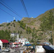
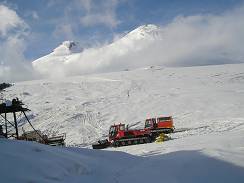
Mt. Elbrus2005-09-14. Ravil Chamgoulov 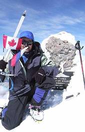 Long flight across the Atlantic Ocean ferried me to Moscow, the capital of Russia. The Kremlin was a residence of Russian Tsars for hundreds years. Now it was a residence of former KGB chief President Putin. I spent a night in Moscow, and next morning, on September 14-th, 2005 I was in the airport again to fly to the Caucasus Mountains. It was not the best time to climb Mt. Elbrus, because the weather is not stable. The best season is since the middle of July till the middle of August. But I didn't have other option: I was in a business trip to attend an international scientific conference, and just took a week of vacation for the climb. Anyway, five days later I was on the top of Mt. Elbrus. I boarded a plane that flew to Mineralniye Vody airport- the gate of Caucasus. From Mineralniye Vody I took a bus to Nalchik – the capital of Kabardino-Balkariya, autonomous republic in Elbrus region. I will skip my adventures along this travel; they just confirmed the simple truth I was well aware about: never travel alone in Caucasus. By midday I was in my friend’s home in Nalchik. I left my backpacks and rushed to buy food and fuel for my trip, and a ticket for the morning bus. But the main thing I needed to do was to obtain a permit from the local frontier troops to visit Elbrus area, since Elbrus is located near the Russia- Georgia boundary, and nobody is allowed to be there without such permit. (Usually travel companies take care about it, but I didn’t use service of any company). Luckily I received the document the same day and was ready to continue my journey. In the morning, September 15-th I took a bus to Terscol, then a taxi to Azay village. A chair-lift to Elbrus slopes starts in Azay village. (04) The chair-lift has three stations on its way up to the mountain. After the first section, which is equipped with gondola, one starts seeing the double-headed summit of Mt. Elbrus. (05)
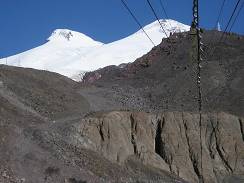
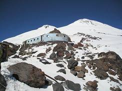
The last chair-lift section brought me to station “MIR”, 50 meters from which the base camp “Barrels” is located at the altitude 3,900 meters. (06) Gigantic fields of crevasses surrounded the place. (07) Barrel-shaped huts provide climbers with good protection from wind and bad weather. I paid for a place in the barrel (equivalent of $10 US per day), left my backpack, and ascended to the next camp “Priut of eleven” for acclimatization.
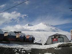
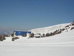
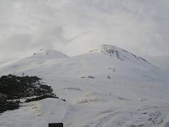
“Priut of 11” (08) at the altitude of 4100 meters used to be a refuge for mountaineers on Elbrus for more than sixty years. However a fire that happened in 1990-th destroyed the refuge, and now there are only the remains on the old place. Several new small huts were built at the location during the last years. I stayed in one of them (09) three days later on my summit day.
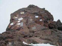
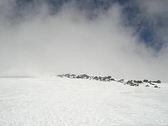
Several meters from the "Priut of 11" there is a rock with a memorial plates with names of climbers who died on Elbrus slopes. (10) There is no cemetery here, just the plates in memory of some of them. Elbrus is a dangerous mountain. Unpredictable weather and hidden crevasses might kill even very experienced mountaineers. (Recent sad news from Elbrus: on May 09th, 2006 eleven climbers died being trapped by a bad weather in the saddle between the West and the East summits.)
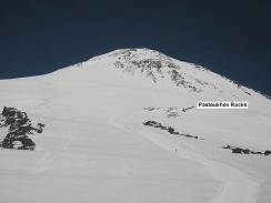
Next day after arrival to “Barrels” I climbed to ”Pastouckhov Rocks” (11) for acclimatization. “Pastouckhov Rocks” at the elevation 4700 meters is a natural reference point on the route. It is located half way from the “Barrels” to the summit. Nowadays commercial expeditions provide their clients with a ride on snowmobiles (12) from the “Barrels” to the Rocks. The last 900 meters of elevation clients gain by feet. A frustrating practice.
The weather was not very stable. When I reached the bottom of the Rocks, the wind brought clouds, (13) which immediately covered the slope.
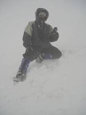
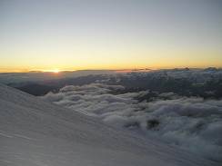
In the evening the weather didn’t look too promising (14), however I decided to climb next morning. I started the accent at 1:30 am. By the dawn I was above Pastouckhov Rocks. Dense clouds limited the visibility to less then 10 meters. I couldn’t see the next mark from the previous one (15, 16), they were on the distance about 30- 50 meters with each other. The route is not the same every year; it is changing with the glaciers motion. I climbed Mt. Elbrus four times in the previous years, and the situation is always different. I kept follow the virtual line from the previous marks, and was able to stay on the trail. Finally I reached the saddle. My altimeter indicated 5,250 m. I was very tired from the hard physical work and luck of acclimatization. It was only my third day in the mountains. The weather wasn’t improved, it was getting worse. I made a picture of myself, (17) and began a descent. I was fortunate enough to find the way down without a delay.
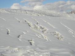
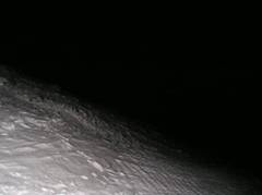
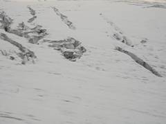
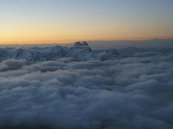
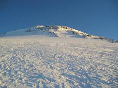
Tired from the previous climb, I spend the next day mostly resting at the Barrels, recovering from the dehydration and the energy loss. In the evening I relocated from the Barrels to a small hut at 4,100 m in the "Priut of 11" area in order to save time for the next morning ascend. I started the climb at 2 am with almost clear sky. In 45 minutes I was at the bottom of Pastuckhov Rocks. After yesterday stormy weather, all footprints were hidden under the snow. However till the bottom of the Rocks I was able to divine the snowmobile tracks, with only 7-8 cm of fresh snow above the compacted surface. Along the Rocks I continued the climb mostly in a knee-deep snow. I was alone on the route, only the mountain and me. That usually gives me some extra sense of nature, but one of the prices for that is a hard strenuous work on cutting the steps in a deep snow. My pace slowed down though I moved without stopping. Some time later I reached the upper edge of Pastuckhov Rocks, and tried to find rods, which mark the trail. My headlamp illuminated not great spot around me. Otherwise it was completely dark. (18) To tell the truth, I didn't expect to reach a top of the Rocks before the dawn. Next part of the route from the top of Pastuckhov Rocks to the saddle between West and East summits is the most dangerous one. Beginning from the elevation 3,500 meters Mt. Elbrus is covered by glaciers with the total area of about 150 square kilometers. Huge crevasses are everywhere; most of them are hidden under snow. (19) is a picture of the area in daylight. The trail carefully marked by rangers passes among those crevasses to the saddle, sometimes a couple meters from crevasses or on the snow bridges above the hidden ones. The climb itself is not technical. Elbrus's icy slopes are not steep generally. The steepness amounts 35 degrees only in some areas above 4,000 meters. The problem was that I couldn't find the marks in the darkness. I had a choice to wait for a dawn, or to move without a trail. The direction was clear for me. I removed a ring from my ski pole and continued the ascend using the ski pole as a probe to check for hidden crevasses in front of me. Being alone I couldn’t afford to make a mistake by falling down into a hidden crevasse through a snow bridge. By 6 am the sky on the East became lighter (20), I saw a beautiful peak Ushba far away. (21) I was above the clouds, and the sky overhead was clear.
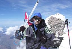
At 7 am the sun rose up on the horizon, and immediately it became very light. (22) I saw the marks; I climbed just 30 meters from the trail. Old tracks on the marked trail were covered only with 10 cm of snow, and it was much easier to follow. The picture I took at the moment of sunrise was the last one my camera was able to snap. The camera was dead. Though I kept the camera in the inner pocket to prevent it from cold, my night pictures had required too much from the batteries and a LCD display. Changing batteries with the spare ones didn’t help. That was not so good, but what could I do? With the daylight and the marked trail my pace became faster and two hours later I reached the saddle. Looking back I saw a couple below, which followed my steps. I waited for them to ask if they have a camera. They had one. That was better. I continued to the West summit, and the couple stayed on the Saddle to melt some snow for drink. They joined me on the summit, and thanks to the young couple who put my memory card into their camera, I have some pictures from the top of Elbrus. (23)
Please log in to post your comment All comments: 0 | Welcome Dr. Ravil Chamgoulov is an elite world-class high-altitude climber who was awarded the rare and prestigious Soviet Union designation of ‘Snow Leopard’. High-altitude ... | ||||||||||||||||||||||||||||||||||||||||||
|
| |||||||||||||||||||||||||||||||||||||||||||
| |||||||||||||||||||||||||||||||||||||||||||